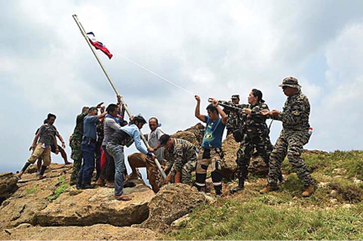


A GRAND plan is now in motion to establish a permanent presence and “effective occupation” by Filipinos of Mavulis Island in Itbayat, Batanes, in the northernmost portion of the country, thus underscoring its geographic, economic and security importance.
Once the internal conquest is completed, the blueprint for what is known as the country’s “northern frontier” should serve as a template in the development of the six islets in the West Philippine Sea, excluding Pagasa Island, which is already populated by Filipinos.
 During the time of retired Lt. Gen. Juancho Sabban as commander of the Armed Forces of the Philippines Western Command, the military pushed for the development and even habitation by Filipinos of the six islets and two shoals in the territory that is being disputed by China.
In endorsing, in late 2017, the House bill seeking to declare the Kalayaan Island Group (KIG) “alienable and disposable” land for agricultural, residential and commercial purposes, then Majority Leader Rodolfo Fariñas said the islets and reefs have a total land area of 79 hectares, including the biggest island called Pag-asa (32.7 ha). The six islets are: Likas, 18.6 ha; Parda, 12.7 ha; Lawak, 7.9 ha; Kota, 6.45 ha; Patag, 0.57 ha; and Parata, 0.44 ha.
The two shoals also considered part of the KIG are Ayungin (Second Thomas) Shoal, where a rusting, former hospital ship was lodged by the AFP as the country’s sentinel amid Chinese incursions; and Rizal (Commodore) Reef.
While the tack was intelligently devised to solidify the country’s ownership of the Beijing-contested features and morph it into a purely civilian issue away from a heated security dispute, this scheme was never pursued by the two previous administrations.
 Thus, what is known as the Philippines’s Kalayaan Island Group is in a perpetual stage of geopolitical limbo, officially owned by the Philippines but living in the perpetual shadow of a hegemonic neighbor from the northeast.


Lighting up Mavulis
Philippine officials apparently have a more deliberate plan for the so-called northern frontier. As the penultimate phase in the occupation by Filipinos of the Philippines’s own territory, the Armed Forces Northern Luzon Command is moving to energize Mavulis, a 4-square-kilometer jagged island, with the help of other stakeholders, especially in the private sector.
Lt. Gen. Emmanuel Salamat, commander of the Nolcom, is expecting to sign a memorandum of agreement with the One Meralco Foundation for the installation of power through solar photovoltaic (PV) technology in the multipurpose facility that it is building on the island.
The initiative forms part of a larger plan to deploy and sustain the presence of regular soldiers in the island and to encourage residents of Batanes to settle there, thus establishing effective control by Filipinos over the rich island.
The solar PV equipment should provide sustainable power for the lighting and communication systems requirement in Mavulis, the significance of which the Nolcom—in partnership with other stakeholders—has been working to create awareness among Filipinos.
Development challenges
The construction of the multipurpose facility, including a fishermen’s shelter in the most isolated and northernmost uninhabited island of the country, began early this year with the help of stakeholders, both in the public and private sectors.
According to Lt. Col. Isagani Nato, Nolcom spokesman, the building of the facility was quite a challenge for them, given the daunting obstacles posed by nature and the extreme activities that had to be done, especially compounded by the island’s isolation.
He described it as, “a difficult task to meet as the ground work and transportation are affected by the weather and proximity of the island to its adjacent inhabited island of Itbayat,” he said.
“The Mavulis project has a unique set of works program being monitored on a weekly basis since it started. It allows flexibility of sequence as it engages stakeholders’ efforts in the share of construction materials,” he added.
Due to the bad weather throughout the adventurous “ship-to-shore” unloading of materials, the project is still way below its originally intended completion period.
“The completion of the fishermen’s shelter will increase presence of local fishermen in the region, contributing to the protection and management of our marine resources, as well as enhancing the information gathering around this northern maritime area,” Nato said.
Economic benefits
Owing to its richness, the military and the municipal government of Itbayat have been working to secure Mavulis (or Mavudis to the locals) away from foreign poachers and intruders—including Vietnamese, Chinese and Taiwanese—for the economic benefits of Batanes and even its adjoining provinces.
Salamat admitted that before the military began carrying out its maritime domain awareness missions, basically through patrols in the latter part of 2016 with the arrival of assets and equipment for the Armed Forces, the island has been irregularly populated or visited by fishermen from the three countries.
Apart from wild goats that used to dot the island before they were hunted and eaten by the foreign intruders, Mavulis’s surrounding waters are home to rich stocks of fish of various species, the main reason poachers are lured into them.
A first visit by soldiers and officials of Itbayat to the island in 2016 unearthed trash with Chinese markings, which indicated the regular presence of Chinese visitors in the area.
“We are very thankful for this visit. We have been looking forward to this for decades and I hope that our presence out there will be sustained because we can only do so much in preserving our territorial integrity, as well as our source of livelihood, which is fishing,” former Itbayat Mayor Ruelle Ibañes said then.
Ibañes complained that local fishermen were being intimidated by the presence of foreign poachers in bigger vessels.
The situation, however, gradually changed beginning in 2017, as the Nolcom sustained its maritime patrol in the country’s northern waters, with no less than local officials reporting about the decreasing presence of foreign fishermen in the area.
“Our scarce resources and means in protecting our own territory was obliterated by the AFP’s genuine concern [for] our people by keeping our people safe and free from threats of foreign poachers,” the Batanes provincial government wrote the Nolcom.
The air and sea patrols by the Air Force and the Navy, and even by the Philippine Coast Guard, were being conducted, both for territorial operations and for the government’s effort to provide a fishing haven for Filipino fishermen.
‘Security Goliath’
More than the economic benefits offered by Mavulis to the residents of Batanes, the imposing rock-like feature still provides the country a feeling of even just a small ounce of security in the face of a Chinese march in the West Philippine Sea, especially if it will be developed into a full and complete military installation.
Mavulis, as strategic military planners have described it, should be the “retreating ground” and the last security defense for the military, if and when Beijing occupies the territory that it insists it owns, and this includes even Scarborough Shoal near mainland Zambales.
Mavulis borders Taiwan and sits on the Bashi Channel, which connects the West Philippine Sea or even the South China Sea and the Pacific Ocean.
The Bashi Channel is considered as a strategic waterway that the Chinese Navy, including its submarines, have to cross in the unlikely event that they will attack American forces in Guam and Hawaii, thus highlighting its importance not only for the country, but for its allies.
Image credits: Photos courtesy of the P.I.O., Northern Luzon Command, Armed Forces of the Philippines